


Pix4D Survey
- Brand: Pix4D
- Product Code: Pix4D Survey
- Availability: In Stock
-
£210.73
- Ex Tax:£175.61
Available Options
Pix4D Survey
Bridge the gap between photogrammetry and CADCapture
Capture images or point clouds with a drone or any laser scanner.
When using a drone, automate and optimise your flights with the free PIX4Dcapture mobile app.

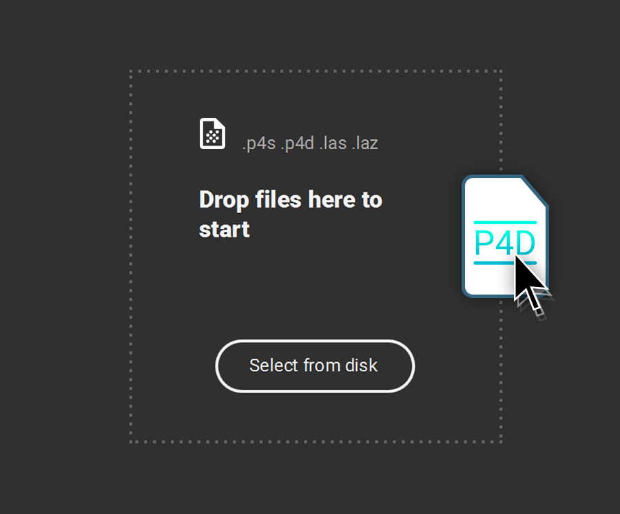
Import
Import data from other Pix4D software or a .las or .laz file to PIX4Dsurvey and combine multiple datasets into the same project.
Work with both imagery data and LiDAR point clouds.

Vectorise
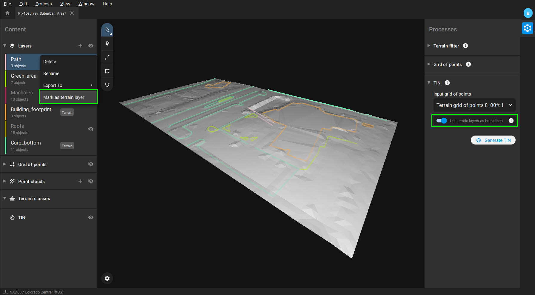
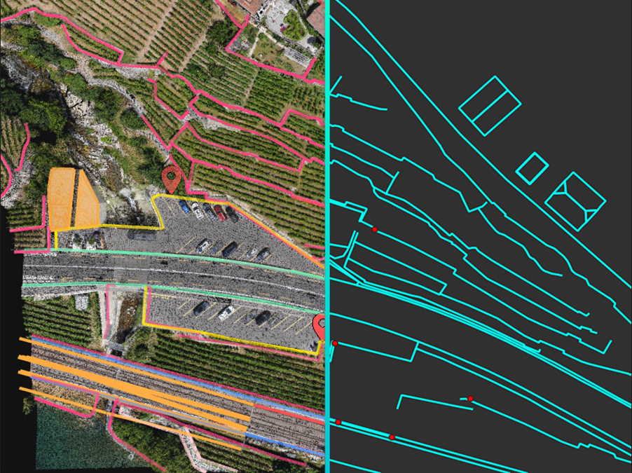
Generate a TIN to model the ground and create engineering-ready CAD vector files from point cloud data by extracting key elements of your project with PIX4Dsurvey.

Model
Move from a lightweight point cloud to a model of your terrain. Use the Smart Grid, TIN, and terrain classification to get accurate, actionable results

Integrate
Open your simplified, accurate data in any CAD or GIS software with custom layers and properties that fit your existing workflow.

Beyond the point
Extract only the most relevant information to speed up and simplify your surveying workflows
Vectorise anything
Use the combined power of images and point clouds to extract key elements from photogrammetry, laser scanning or LiDAR data. Survey curbs, building footprints, walls, catenary curves and more.
Time-saving benefit
Work 50% faster when you vectorise from point clouds and verify in images, while the Smart Grid saves 1,000s of clicks creating spot elevations.
CAD Ready
Include layers and properties for a smooth transition to CAD or GIS and reduce file size when exporting your projects as vector files.
Volume Measurements
Create and measure the volume of any object, even against a wall or in a corner, with fast, simple steps.
Extract Key Elements in 3D
Built-in Vectorisation Tools
Vectorise your project using points, polylines, polygons and catenary curves with just a few clicks.

Measure Volumes
Measure the volume of any object or space with straightforward steps.
Create Surfaces
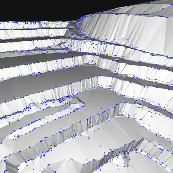
Model the ground with a TIN from points and breaklines to represent the topography of your project. Automate the creation of spot elevations and allow drastic simplification of the number of point cloud points.
Unlock More Data
Move beyond photogrammetry, yet still work with Pix4D’s rayCloud to access the original images and 3D point clouds simultaneously. Vectorize in 3D, edit in 2D. Survey complex objects only visible in images. Use colour selection to pick a point and search in a defined radius for points of a similar colour.
Scale Up
PIX4Dsurvey can handle billions of points. Work with as many point cloud files as you like in the same projects, including .las.
Integrated Solution
PIX4Dsurvey works with your existing workflows. Import .p4d files from PIX4Dmapper, PIX4Dcloud, or .p4m files from PIX4Dmatic with the click of a button, or work with .las and .laz files from any device/source.
Easy Export
Every surveyed object can be assigned to a layer and edited. Layers can be exported separately or together for a smooth transition to your preferred CAD or GIS software.
Your choice of point cloud
Import projects from PIX4Dcloud, PIX4Dmatic, PIX4Dmapper or any .las or .laz file.
Aerial data
Create a point cloud from images in PIX4Dcloud, PIX4Dmapper or PIX4Dmatic, and drag and drop the .p4d or .p4m file to PIX4Dsurvey.
Laser scanner or LiDAR
PIX4Dsurvey works with multiple point clouds at the same time formatted as an .las or .laz file.
From point cloud to TIN in a fraction of the time
Automate the creation of spot elevations and allow drastic simplification of the number of point cloud points. With a click, use this Grid of points to model the ground with a TIN.
Extract the same points you would use in the field with Smart Grid - it doesn't create any data, but instead reads the terrain class for locations of elevation change, just like your field crew would take spot elevations along breaklines.
Next up? Take that set of points & breaklines and create a DTM in LandXML format that exactly reflects the points you have told it to use. Now you are good to go in your CAD or GIS!
What's Included?
Desktop application with floating license (use on 1 device)
Personal support and upgrades included during your subscription from Pix4D.
What happens when I buy this product?
You will be sent your product key in .pdf format within 1 working day.
Where can I redeem my product key to start using Pix4D Survey?
You can redeem your key here: https://account.pix4d.com/redeem
You will need to have an account and be logged in.
What is PIX4Dsurvey?
PIX4Dsurvey bridges the gap between photogrammetry and CAD. It does so by providing access to the original images and the point cloud through the 3D view to vectorise and extract points, polylines, polygons and catenaries for a shorter time to delivery. Additionally, PIX4Dsurvey supports very large datasets or a combination of many datasets with an optimal experience.
The software expands today’s possibilities by enabling the combination of photogrammetry and third-party point clouds such as terrestrial laser scanners.
What is the difference between PIX4Dsurvey, PIX4Dmapper, and PIX4Dmatic?
The main difference is that PIX4Dmapper and PIX4Dmatic are primarily photogrammetry processing software, while PIX4Dsurvey is a tool for the vectorisation of geospatial data.
Together they cover the complete workflow for transforming the acquired information (images, point clouds) to a deliverable suitable for CAD or GIS software.
Can PIX4Dsurvey process data?
PIX4Dsurvey does not calibrate the photogrammetric projects or generate dense point clouds. This is done by photogrammetric software PIX4Dmapper and PIX4Dmatic.
On the other hand, it is possible to post-process dense point clouds in PIX4Dsurvey by running Terrain filter and Grid of points processes.
Can PIX4Dsurvey extract terrain points and generate a DTM?
Yes, PIX4Dsurvey can classify point clouds into terrain and non-terrain classes and generate a representation of the ground surface by only using the terrain points. The workflow is the following:
Terrain filter to classify selected input point clouds into terrain and non-terrain points.
Grid of points to automate the creation of spot elevations. Using the Smart type creates points only where changes in terrain occur.
TIN is a seamless set of triangles that represent a surface. When using only terrain points, the generated surface is a DTM.
The TIN can be exported as a surface in LandXML file format, which is fully compatible with CAD software.
What is the difference between PIX4Dsurvey and CAD software?
The main difference is that PIX4Dsurvey supports the seamless import of PIX4D projects with accurate results and images.
Unlike CAD software with its focus on design, PIX4Dsurvey provides vectorization and extraction tools and is optimized for handling and manipulation of very large datasets and point clouds.
Can PIX4Dsurvey replace the CAD products I typically use?
No. PIX4Dsurvey makes it easier to move from photogrammetry to your CAD product.
Can I import the vectorised data into CAD software?
Yes, PIX4Dsurvey exports vectorised data that can be seamlessly imported into CAD or GIS software using .dxf and .shp format.
You can import .dxf files into PIX4Dsurvey and use them as a reference and a base for vectorisation. Snapping on existing vertices is supported, so you can really take advantage of the preexisting data.
Do I have access to PIX4Dsurvey if I have other PIX4D licenses?
PIX4Dsurvey is not included in the PIX4Dmapper or PIX4Dmatic licenses.
What hardware specifications do you need to run PIX4Dsurvey?
Minimum configuration for PIX4Dsurvey
Windows 10 / 11, macOS Big Sur or Monterey.
Any CPU (AMD processor or Intel i3, i5 or higher).
Any GPU that supports OpenGL 4.1 or higher.
RAM: 16 GB.
Free hard drive space: 10 GB on HDD.
Recommended configuration for PIX4Dsurvey
Windows 10 / 11.
CPU: Quad-core or hexa-core Intel i7/ i9/ Xeon, AMD Threadripper.
GPU: GeForce GTX GPU compatible with at least OpenGL 4.1.
RAM: 32 GB. (64GB if the point cloud size > 100 GB).
Hard disk: SSD.
How many computers can be bound to the same account?
Each PIX4Dsurvey license is paired with a Pix4D account. It can run on one computer at a time, but the license is floating and can be used on any computer. PIX4Dsurvey needs to be closed before you will open it on another device.
Does PIX4Dsurvey run on the cloud or locally?
PIX4Dsurvey is a desktop-only application that runs locally on Windows or Mac.
How can I share my PIX4Dsurvey projects?
It is possible to share PIX4Dsurvey projects over the internet using the Share to PIX4Dcloud tool.
Can I use PIX4Dsurvey with no internet connection?
Not currently, but this is planned for future releases.
For now, an internet connection is required for the login, when opening the application and when closing the application. If there is no internet connection at application closing, the license will not be released, and it is not possible to access it from another device.
If a computer has not released a license you can remove it through your Pix4D account:
Go to Pix4D's Website -> Login -> Click on your account icon in the top right -> Account -> Plans and licenses -> Licenses Tab -> Manage Licenses -> Under Active Devices Click the bin icon next to the computer you want to release the license from.
What are the inputs and outputs of PIX4Dsurvey?
PIX4Dsurvey allows the import of PIX4Dmapper and PIX4Dmatic projects, as well as independent .las or .laz files. It is also possible to import .dxf files with 2D and 3D objects.
File types supported: .dxf .shp .geojson .json .las .laz .txt .csv .xyz .p4d .p4m .p4s
The main output of PIX4Dsurvey are .dxf and .shp files that can be seamlessly imported in CAD or GIS software.
What is the default coordinate system in PIX4Dsurvey?
While PIX4Dsurvey requires a projected coordinate system, there is no default system. When a PIX4Dmapper project is imported, PIX4Dsurvey will use the coordinate system defined in the PIX4Dmapper project file.
What to do if "Las coordinate system unknown" error appears?
When importing an external point cloud, the coordinate system information needs to be written in the .las file.
If you are trying to import the external point cloud into an existing project that was previously created using the PIX4Dmapper project, then the import is still possible. Just make sure that the coordinates of the external point cloud are in the same coordinate system as specified in the PIX4Dmapper project.
If you are importing an external point cloud in an empty project, then you need to make sure the coordinate system is written directly in the .las file.
What is the largest point cloud I can import into PIX4Dsurvey?
You tell us! What you can process depends on your system resources, Pix4D have successfully tested single file imports of 1.8 billion points on laptops, and more than 4 billion points in total.
Is it possible to align multiple point clouds?
Yes, different point clouds can be aligned using the Project registration tool.
Playlist from Pix4D of some of the features Pix4D Survey has:

A2 Certificate of Compete..

GVC Drone Training - Gene..

Parrot ANAFI Ai 4G Unlimi..
Pix4D Mapper

Pix4D React

PIX4D Fields

Pix4D Matic