


Pix4D React
- Brand: Pix4D
- Product Code: Pix4D React
- Availability: In Stock
-
£47.27
- Ex Tax:£39.39
Available Options
Pix4D React
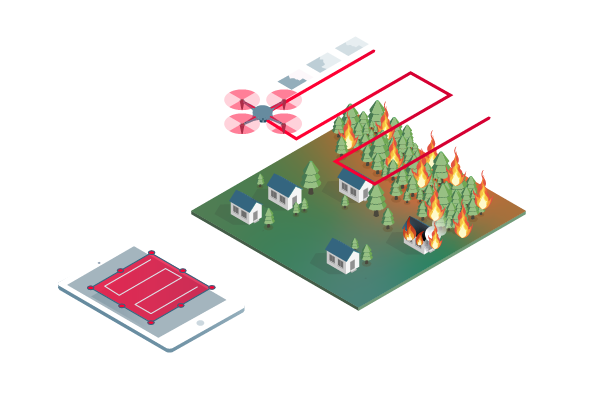
2D fast-mapping for emergency response and public safetyCapture
Fly your drone to capture the images you need. Plan an optimized and automated flight with an app like PIX4Dcapture for Parrot and DJI drones.
Process
Combine large numbers of images in minutes with PIX4Dreact. Create measurable 2D maps in the field or back at base.

Examine
With PIX4Dreact’s simple tools, identify and measure points of interest, mark and evaluate your maps while on the ground to provide powerful data needed to take action.

Share
Export your maps to ensure teams and decision makers are provided with effective information when it’s needed most.

Respond
With up-to-date maps, gain precious time, improve safety and reduce costs when responding to an evolving situation.
The mapping software for emergency response
Get rapid and reliable situational awareness for quick decisions and collaboration in the field.
Fast
PIX4Dreact creates 2D maps from aerial imagery in minutes. Because when every second counts, up-to-date and reliable information is of utmost importance to teams on the ground.
Easy to use
Simple and intuitive to use, even in complex and stressful situations. PIX4Dreact is developed with public safety and humanitarian aid professionals to meet their unique challenges.
Lightweight and robust
Lightweight enough to work on a mid-range computer in the field. PIX4Dreact doesn’t rely on an internet connection or the cloud for processing.
Share findings
PIX4Dreact outputs can be uploaded to PIX4Dcloud for sharing. Export your maps and reports and seamlessly send them to colleagues or teams on the ground.
Reliable situational awareness in complex situations
Fast and intuitive mapping
Get a fast aerial overview of the scene in minutes without internet. Overlay the US national grid to your maps to make them universally understood.
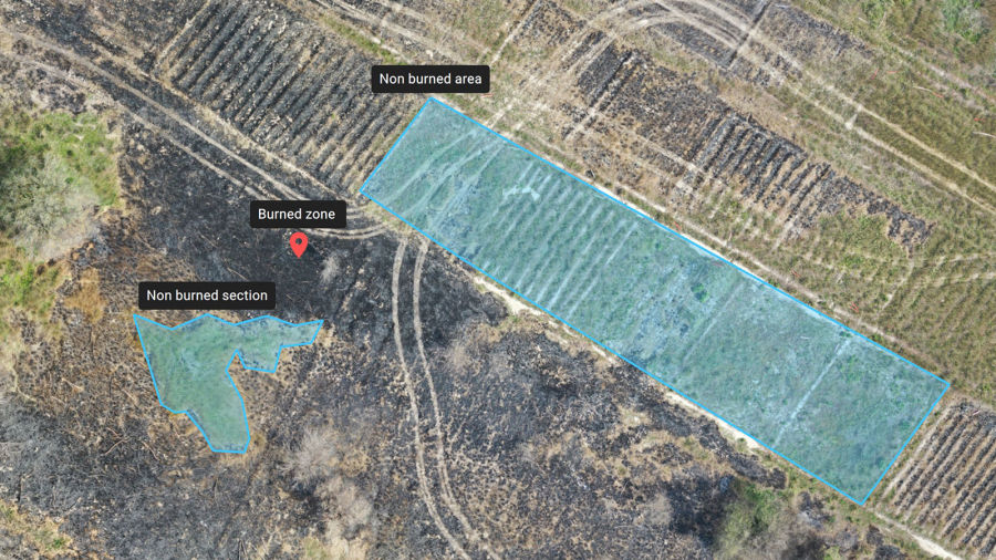
Measure and mark areas of interest
Connect your maps with what you see on the ground. Rely on powerful rapid insights directly from the field and easily mark and measure points of interest.
Compare maps
Use a split or swipe view to compare your aerial and elevation maps. Add a standard or a custom base map for an additional level of comparison.
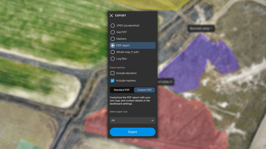
Fast and easy export
Share 2D orthomosaic maps and annotations as a PDF report which are lightweight enough to send over email.
Share to PIX4Dcloud
Upload PIX4Dreact outputs (orthomosaic, surface model) directly to PIX4Dcloud for sharing.
Fit for purpose
Use PIX4Dreact as a stand-alone 2D fast-mapping software, tailor-made for emergency response or together with PIX4Dmapper for extra analytical functionality.
The map you need when you need it
Ensure teams and decision makers are provided with timely and effective information needed to take action
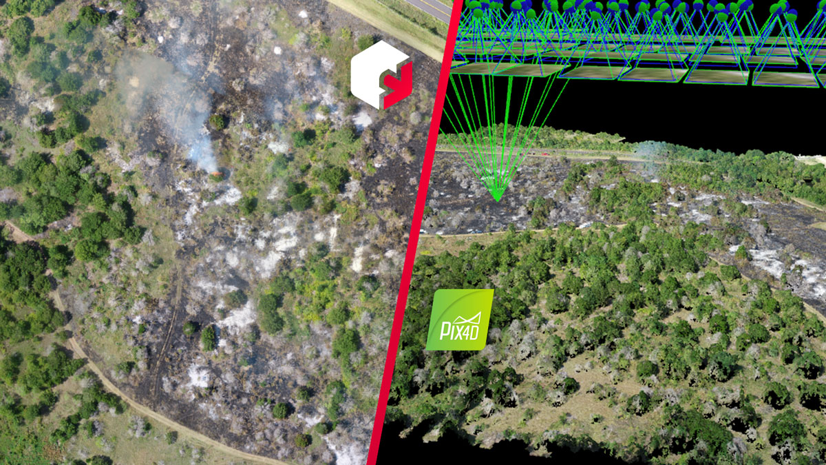
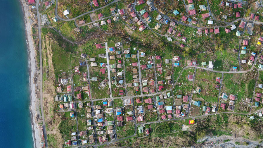
2D orthomosaic map
PIX4Dreact uses fast-stitching technology to create accurate 2D orthomosaic maps by combining a large number of nadir drone images.
Export format: geoTIFF
Markers and measurements
Mark areas of interest or GPS coordinates within the project and assess the situation on the ground for smoother collaboration or long-term documentation.
Markers export formats: GeoJSON, KML, Shapefile
Measurements export format: PDF
Screenshots and whole maps
Document and collaborate in seconds with options to export your maps as screenshots or a whole map that can be imported into PIX4Dreact on another computer.
Screenshots export format: JPEG
Whole maps export format: p4r
PDF Report
Easily share a 2D orthomosaic, location data and markers in one file over email. Customize the report by white labelling it with your company details and logo.
Export format: PDF
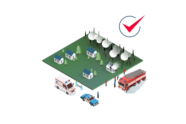
Helping emergency teams on the ground
Developed with the help of emergency responders, PIX4Dreact is designed to be the optimal 2D fast mapping software for public safety and humanitarian aid professionals
Earthquakes
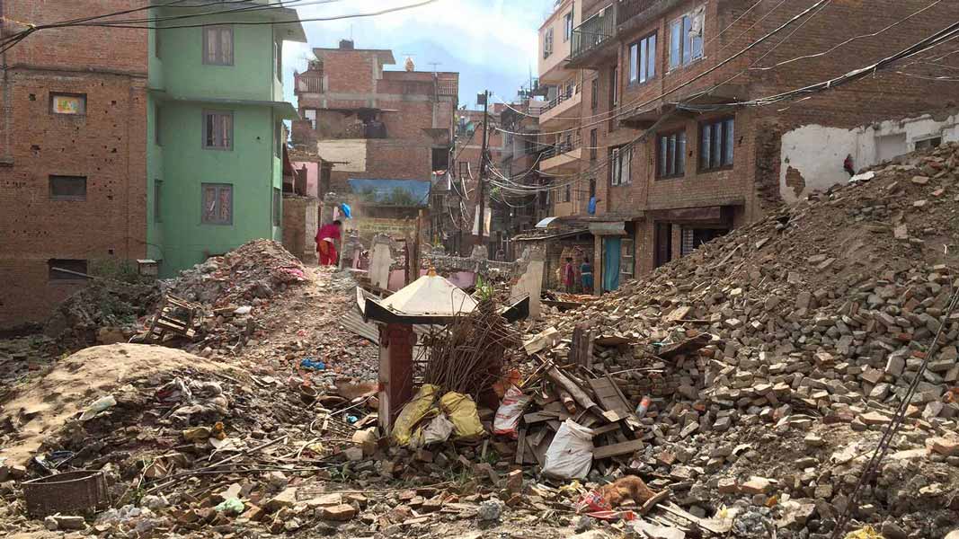
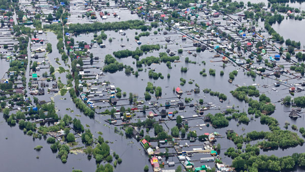
Flooding
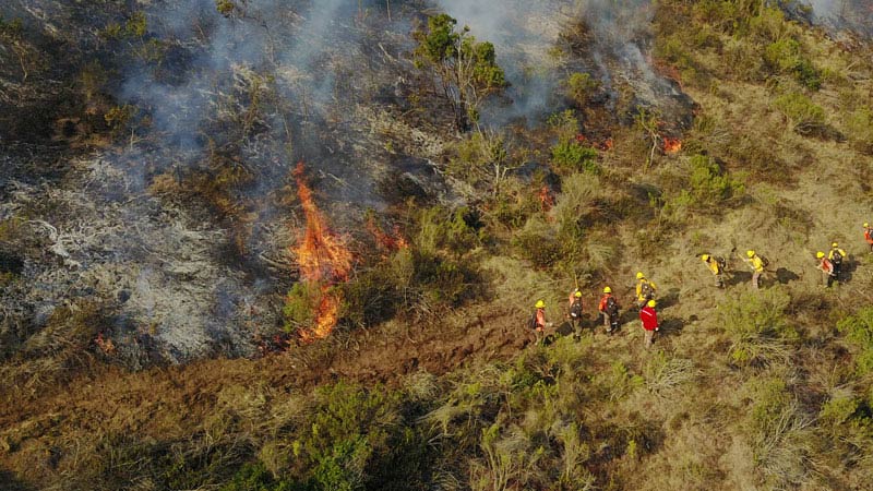
Fires
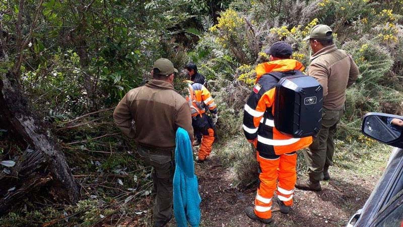
Missing persons
Tactical planning

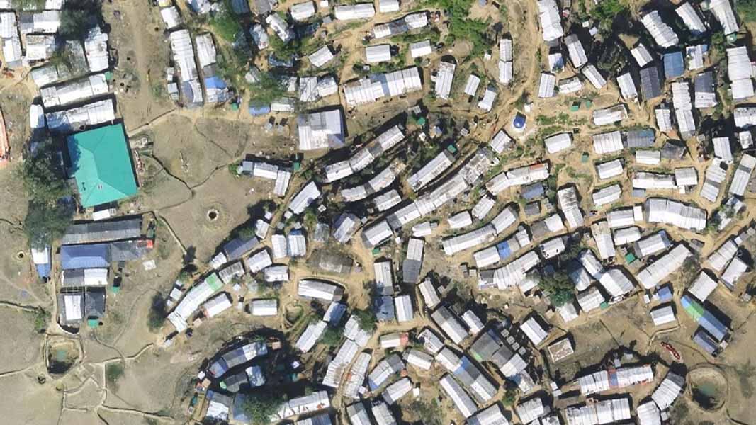
Human displacement
What's Included?
Desktop application with floating license (use on 1 device at a time)
Unlimited desktop processing and high-resolution outputs.
Personal support and upgrades included during your subscription from Pix4D.
What happens when I buy this product?
You will be sent your product key in .pdf format within 1 working day.
Where can I redeem my product key to start using Pix4D React?
You can redeem your key here: https://account.pix4d.com/redeem
You will need to have an account and be logged in.
What specs does my computer need to run Pix4D React?
Recommended
CPU: Intel® Core™ i5 or AMD Phenom processor (or faster)
GPU: Integrated or dedicated GPU with 2 GB RAM (GeForce GTX with 6GB RAM or better recommended for faster processing of data)
RAM: 8 GB RAM (or more)
Hard disk: 4GB HDD free space (more for large datasets). SSD recommended.
Operating system:
MacOS: macOS Catalina (10.15) or above.
Windows: Windows 10 (64 Bit) or above.
What Cameras are supported?
Most DJI/Yuneec/Parrot drones will work with Pix4D
A non-comprehensive list of cameras from DJI/Yuneec/Parrot as of 17/05/23 are:
Parrot Anafi Ai
Parrot Anafi USA
DJI Spark
DJI Mini
DJI Mavic Air
DJI Mavic Air 2
DJI Mavic Air 2S
DJI Mavic Pro
DJI Mavic Enterprise Dual
DJI Mavic 2 Pro
DJI Mavic 2 Enterprise Advanced
DJI Mavic 3
DJI Mavic 3 Enterprise M3E
DJI M30T
DJI Phantom 3
DJI Phantom 3 Adv
DJI Phantom 3 Pro
DJI Phantom 4
DJI Phantom 4 Pro V2
DJI Phantom 4 Pro
DJI Phantom 4 RTK
DJI Zenmuse P1
DJI Zenmuse H20T
DJI Zenmuse X3
DJI Zenmuse X5
DJI Zenmuse X5RAW
DJI Zenmuse X4S
DJI Zenmuse X5S
DJI Zenmuse X7
Yuneec E90 (H520)
AeroVironment
Autel Evo I
Autel Evo II 8K
Autel Evo II Pro 6K
Autel Evo II V3
Autel Evo II Dual
Sony Alpha 7R IV
Skydio Skydio2/2+
Skydio X2
ACSL Soten
senseFly albris
senseFly S.O.D.A.
What is PIX4Dreact?
PIX4Dreact is a fast-mapping desktop software that rapidly processes drone-captured images into accurate 2D maps when time is of the essence, and internet connectivity is not available. PIX4Dreact is designed for public safety, emergency management, humanitarian, and disaster relief to improve situational awareness and provide critical information.
How does PIX4Dreact work?
PIX4Dreact turns drone images into a 2D map. To achieve that, the software uses a direct-to-orthomosaic photogrammetry technique optimised for fast processing of mostly flat terrain from drone imagery. By focusing on this specific output, high-quality maps can be processed in a fraction of time thereby providing immediate situational awareness while still on-site using a laptop.
What specs does my computer need to run Pix4D React?
Recommended
CPU: Intel® Core™ i5 or AMD Phenom processor (or faster)
GPU: Integrated or dedicated GPU with 2 GB RAM (GeForce GTX with 6GB RAM or better recommended for faster processing of data)
RAM: 8 GB RAM (or more)
Hard disk: 4GB HDD free space (more for large datasets). SSD recommended.
Operating system:
MacOS: macOS Catalina (10.15) or above.
Windows: Windows 10 (64 Bit) or above.
Will my hardware affect the quality of my maps?
The image processing speed is directly correlated with the performance of your hardware. The quality of the generated map will not be affected by different hardware configurations.
How many computers can be used with the same account?
Each PIX4Dreact license is linked to a PIX4D account. PIX4Dreact can run on one computer at a time, but the license is floating and can be used to login on any number of computers.
Does PIX4Dreact process the data on the cloud or locally?
PIX4Dreact's fast processing engine processes the data locally on your computer and does not require an internet connection, other than to activate the license for the first time.
Can I use PIX4Dreact with no internet connection?
Yes, PIX4Dreact is specifically developed to convert images into high-resolution maps, with no cloud or internet connection required. However, before using it on a new computer, you will need to activate your license. While connected to the internet, log into your Pix4D account and select a license so that you can use PIX4Dreact. The software will store this license on your computer until it expires, so you can work offline.
Does PIX4Dreact process multispectral or thermal images?
PIX4Dreact does not process multispectral or thermal images. PIX4Dreact supports RGB images
What are the inputs and outputs of PIX4Dreact?
PIX4Dreact allows the import of JPEG images, as well as .p4r files. The full list of input and output files is available in this article.
What’s the difference between a 2D map generated in Pix4Dmapper and PIX4Dreact?
To create an orthomosaic map, Pix4Dmapper takes into account fine-grained local variations in altitude, whereas PIX4Dreact uses a coarser ground model. If there is a significant number of 3D structures in a project area then PIX4Dmapper will give more accurate results. However, PIX4Dreact still gives quality results on any surrounding flat area while generating outputs significantly faster than PIX4Dmapper.
What is the difference between the Digital Surface Model (DSM) generated in PIX4Dreact and PIX4Dmapper?
The DSM generated in PIX4Djmapper produces an accurate elevation value of each pixel, with or without above-ground objects, ready for your preferred GIS or CAD workflow.
DSMs generated in PIX4Dreact capture major ground shapes but are less sensitive to small structures. The absolute altitude of the DSM generated in PIX4Dreact will depend on the quality of the GPS information from the image acquisition.
What coordinate system is used by PIX4Dreact?
PIX4Dreact utilises the corresponding Universal Transverse Mercator (UTM) zone in the WGS84 datum WGS84.
Does PIX4Dreact support Ground Control Points (GCPs)?
PIX4Dreact does not support GCPs. If GCPs are required for improved accuracy and reconstruction, we recommend using PIX4Dmapper.
Can PIX4Dreact process oblique imagery?
PIX4Dreact supports processing nadir images captured with a drone camera pointing straight down. PIX4Dmapper is recommended for processing of oblique images.
My map doesn’t look great. Why?
The quality of a map can be affected by factors such as reflective surfaces in the area (water or glass), or large areas of the same colour or texture (snow or skies).
Note: An overlap of 80% frontal and side is recommended.
Can I edit my maps in PIX4Dreact?
Not currently. It is recommended to export the map and import it into a third-party application such as QGIS or ArcGIS. Future versions will give more fine-grained control.
Can I use non-aerial images with PIX4Dreact?
No, PIX4Dreact can only be used with aerial images, ideally captured by drones.
What if my camera is not supported in PIX4Dreact?
If a camera is not supported in PIX4Dreact, it is still possible to process the dataset if a file with the internal camera parameters is provided.
What is Share to PIX4Dcloud?
Share to PIX4Dloud is a feature of PIX4Dreact which makes it easy to share 2D layers over the internet with just a web link. It enables the connection of a PIX4Dreact desktop project to PIX4Dcloud. A single orthomosaic and/or a DSM can be uploaded to PIX4Dcloud with a valid PIX4Dreact license. All layers will be stored in PIX4Dcloud, and a shareable URL link to the project will be provided after a successful upload.

A2 Certificate of Compete..

GVC Drone Training - Gene..
Pix4D Mapper
Pix4D Survey

PIX4D Fields

Pix4D Matic