


Yuneec ST16E Ground Station RC for H520E YUNST16EEU
- Brand: Yuneec
- Product Code: ST16E
- Availability: In Stock
-
£749.99
- Ex Tax:£624.99
Available Options
Yuneec ST16E Ground Station Remote Controller for the H520E
The Android-based ST16E is equipped with a fast Intel quad-core processor and OFDM support. Thanks to the OFDM support, the live image transmission can be expanded up to 4 kilometers. The integrated 7 inch display with touchscreen ensures precise and intuitive operation of the H520E and shows all flight information as well as the live image from the camera. The live image can also be transferred to a larger monitor via the HDMI output of the ST16E. During the flight, real-time telemetry data such as altitude, speed, distance from home, GPS position and battery status are shown on the display. Controls expected by professionals include adjustable video resolution and white balance, while light exposure can be controlled automatically or manually, including ISO and shutter speed. You can also use the ST16E as a mission planner. Plan your flight using the touch screen, and execute your mission with just a single press of a button. The ST16E supports team mode, allowing one pilot to control the drone while another controls the camera.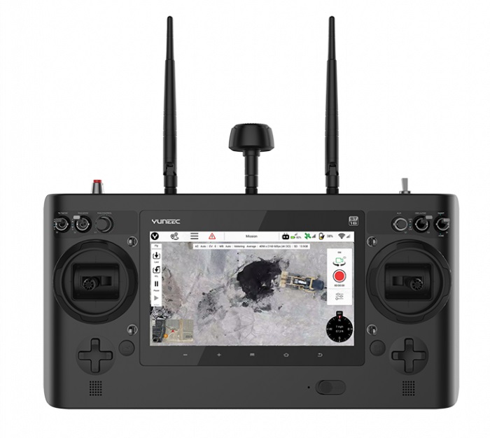
Team Mode
Team Mode allows you to independently control copter and camera via two remote control systems. While the drone pilot continues to take control of the copter, the camera operator can concentrate entirely on the camera. This collaboration greatly facilitates the capture of creative images and provides not only film producers, but also fire departments, inspectors and other commercial users with a helpful tool for making jobs more precise and to work in a team.
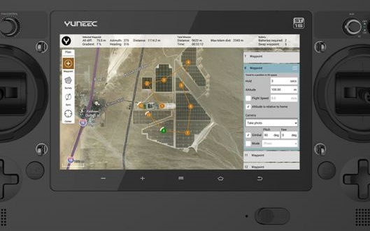
Comprehensive DataPilot™ Software
Yuneec DataPilot™ is a comprehensive software solution for planning waypoint and survey missions, that is fully integrated into the hardware and software of the H520E-OFDM. The DataPilot™ software system enables users to efficiently and consistently create orthomaps, 3D scans, crop data imagery, in the field or on the desktop for repeatable, recallable aerial flight paths, without requiring expensive third party software. Surveillance flights, construction measurements, BIM components, accident reconstruction, 3D scans, orthomosaics and photo stitches are created with high precision and efficiency via the DataPilot interface. DataPilot™ is installed as standard on the ST16E remote control.
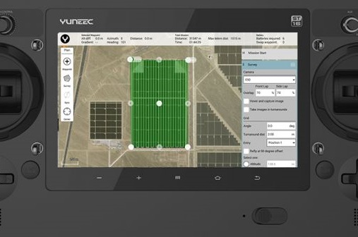
Off-site Planning Of Flight Missions
DataPilot auto-generates survey paths with user-defined frontlap/sidelap, and cross-hatching for precision 3D or large format image output. DataPilot also allows for storage/caching of maps from many map providers for access in areas with no connectivity, and provides tools for precise waypoint placement even in areas where no updated maps are available. Missions/flights may be stored for later recall/reflight, or planned off-site and transported to the control system via email, thumbdrive, or micro-SD card. Mac and PC users may plan missions offsite and execute missions on-site, allowing for time-planning, collaborative mission planning, and archiving of missions in a cloud or local storage.
Operating System: Android
Number of Channels: 16
Transmission Distance Range (Optimum Conditions): Up to 4 km
Battery: 8700mAh 3.6V 31.32Wh Li-Ion
Video Link Resolution: HD 720p
Video Link Frequency Band: 5.8 GHz WiFi
Display Screen: 7"
Tactile and Audio Feedback: Yes
Telemetry Data on Screen: Yes
Connection Types: HDMI x 1, USB x 2, 3.5mm headphone jack
Compatibility:
Yuneec H520E
What's Included?
ST16E Remote Controller x 1

Yuneec RC Neck Strap for ..

Yuneec H520E Flexible For..

Yuneec H520E Battery 6200..